

Keeping up with google can wear you out which sets to make one of its most popular apps – Google Maps – better with new features. Later Google I/O 2018, the mobile mapping app developers got great visionary of maps from the search giant.
The vision of Google maps is all about to become more assistive and personal in nature. Google Maps API, this time has done most of the development changes on the core technology front. Below are some key new features that the great Google Maps came up to integrate into the mobile app for commercial business.
10 Google Map API features
- Street View with Panorama
- Heat Maps
- Style Maps
- Ground Overlay
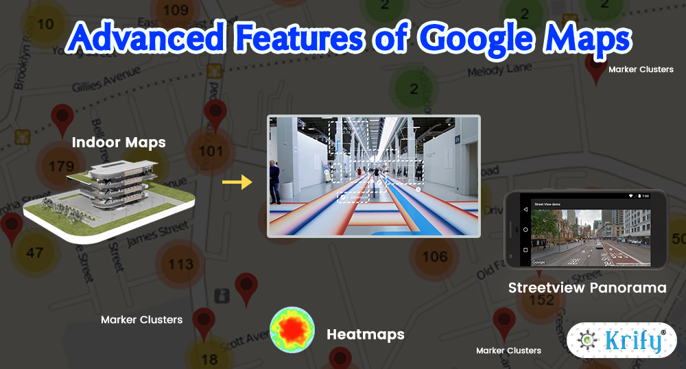
- Indoor Maps
- Marker Clustering
- Multiple Maps
- Animation(Transition Speed)
- Circles
- Auto Lat-longs
Street View Panorama
The Street View panorama service provides all the users with a real-world experience of an address on the map. Google Street View provides panoramic views(360-degree) from designated roads throughout its coverage area.
Heat Maps
Heatmaps are new visualisation available in the utility library. HeatMaps represent geospatial data on a map by using different colours to represent areas with the different group of points. It shows the overall shape and group trends. It is also known as “intensity maps“.
Style Maps
Using Style Maps you can add a map with custom styling to your app. With style options, you can customize the look of the standard Google map styles, changing the visual display of features like roads, parks, businesses and another point of Interest(POI). As well as changing the style of these features, you can hide features entirely, which means that you can emphasize particular components of the map or make the map style of your app. The styling works only on the normal map and does not affect the INDOOR MAPS.
Ground Overlay
Ground Overlays are the images that are attached to latitude or longitude coordinates, so they run when you drag or zoom the map. This is also described as the images are fixed to map. Other than markers, ground overlays are oriented against the earth’s surface rather than the screen, so rotating, tilting or zooming the map will change the orientation of the images. Ground overlays are useful when you need to fix a particular image in one area on the map. If you want to add huge imagery that covers a large portion of the map, you should use Tile overlay.
To add a ground overlay, create a ground lay options object that defines both images and a position. Even you can opt specific additional settings that will affect the positioning of the image on the map. Once you have defined the necessary options pass the object to the google map method to add the image to the map. The added ground overlay method returns a ground overlay object, then you should retain a reference to this object if wanted to modify it later.
Indoor Maps
MapsIndoors is built on Google Maps, which makes the transit from outdoor navigation to indoor navigation completely logically. All the known functionalities and design of Google Maps is brought inside and the user can get directions from any point outside the venue and all the way inside. MapsIndooor can be integrated into existing applications for the mobile and desktop or as a standalone service. With MapsIndoor CMS updating and customising your indoor maps has become easier.
Marker Clustering
When there is a lot of data to show, its bit hard to keep your app from becoming cluttered and messy. One way is to group nearby markers into a single marker cluster. When viewed zoomed in, individual markers are shown. However, as the user zooms out, marker group together into a single cluster marker. You can easily customize the appearance of the cluster maker and individual. It is ideal for visualising a large number of elements on a map whilst minimising cluster. You can see a concise summary of your data when zoomed out and as the markers separate when you zoom in, you don’t lose any details from your data.
Multiple Maps
Which contains more than one map. An added map is used to show an overview of the area of interest that is being studied on the main map. You can even use multiple maps to show different layers of information about a specific area side by side. The portion of an area based on the mouse or touch area of the major map. The number of maps that can be displayed is limited by your hardware. Screen size and graphics processing will manage how many maps can be efficiently used in your app. There is no limit imposed by the runtime.
An overview map shows the extent of the main map at a smaller scale and provides a spatial context for the area of interest. When you sweep a map looking at detail, it is easy to mislay where you started or unable to determine how far away you are from features that are no longer in view.
To create an overview map, do the following:
- Ensure you have the main map component with a uniquely named ID.
- Define an overview map component.
- Handle the range changed event of the major map and update the overview map extent appropriately.
- Optionally presents a graphic on the sketch map that represents the current area of the main map.
Animation(Transition Speed)
As Animations are ruling the world now, this effect came even into maps. The transition speed will impact the whole concept of animation effect in the map. Using this you can set the load time and also the time for zoom in and out for the map. This will help for the map to come into existence as per the time set by the user.
Circles
Circles will represent the area around us where we locate. The style can be varied as per the user need. The circle covers approximately about 20 to 30 km around us. The circle creation can be done as per the requirement. If you consider a building where you locate and for the tracker who wants to track you will see in a circle that covers the area around you. The design can be as doted, plain line or can be dashed line. We can opt this as per our requirement or convenience.
Auto Latitude and longitude
Nowadays tracking the person’s exact location has become a bit difficult, so Google has come up with a new feature named “Auto Latitude and Longitude”. Auto latitude and longitude are used for tracking the person’s exact location, which will automatically take the latitude and longitude values of the area where the person locates. These features need to be integrated by the developers while developing the app.
Wrapping up:
As we are very familiar with the Role of Google Maps in our daily life today. Whether we choose a Google Maps to an app on iOS, Android, or the web, In such scenarios, we suggest you take brief insights of new features as listed above to get integrated into your commercial business apps.
We are an expert Google Maps API developers and ready to help you to integrate Google API’s into the mobile apps with latest and stunning feature to your project. Krify has dedicated Mobile app developers . You come up with your thought we will implement it to your expectaions and get free quotation for your business. Also, have a look at our recent blogs related to the Maps:
https://krify.co/how-to-create-a-gps-navigation-app/
https://krify.co/the-perfect-role-of-maps-in-mobile-applications/


